Municipal Plan for Sustainable Development - BXL 2050
The Mayor and Aldermen approved the Municipal Plan for Sustainable Development - BXL 2050 project on 23 November 2023. This plan sets the spatial course for the city and provides guidance towards a more sustainable and inclusive future.
The illustrations of the Municipal Plan for Sustainable Development - BXL 2050 (in French):
The videos show the story behind the illustrations for the Municipal Sustainable Development Plan (these video are in French and Dutch, with subtitles in French):
The plan is a project for the future with a clear vision that is translated spatially.
It is not a generic plan for the whole area, but one that takes account of the context and unique character of each district of the City of Brussels. The plan is built around 7 clear ambitions covering a wide range of subjects, from fundamental improvements to the environment to strengthening the relationship between the city and its residents. The 'City in 10 minutes' concept is anchored in this plan, with the aim of making the facilities essential to urban life accessible to every inhabitant of Brussels in less than 10 minutes. This tool makes it possible to objectively demonstrate where specific needs must be met. It will be used to support strategic decision-making and will also be a valuable tool for citizens.
To ensure that the plan stands the test of time, the follow-up to these actions has also been carefully considered. In other words, this is not a plan that will be shelved. On the contrary, this plan will evolve and provide the tools needed to remain relevant and be properly implemented in the years to come.
Structured on the basis of 7 major ambitions broken down into themes and sub-themes, the plan highlights various salient diagnostic elements, proposes development vision principles and maps, and assigns the city cross-cutting objectives for the 2030 and 2050 horizons. For each sub-theme, the plan prescribes strategic objectives and a precise action plan with associated drivers and stakeholders, as well as result indicators that will be regularly monitored. An Environmental Impact Report has been produced to clarify the intentions of the plan.
The 7 structuring ambitions of the Municipal Plan for Sustainable Development of the City of Brussels are:
A City that breathes:
Dedicated to climate and environmental themes, to the way the city intends to participate in limiting its impact on the local and global environment and to organise the adaptation of its territory to the consequences of climate change, namely the increase in energy costs, the increase in periods of drought, the generalisation of heat island phenomena and the management of risks related to intense rainfall and flooding.
A City that evolves:
Whose open and built-up fabric prevents and protects the effects of climate change and allows greater agility and adaptability to rapidly changing urban contexts and practices. A City that questions the issues of land petrification and densification in relation to local needs and contexts, the heritage to be preserved and the reconversion potential of the existing, as well as the urban morphologies, development typologies and construction techniques that should be favoured in all future developments.
An open and inclusive City:
That is fully inclusive, aware of and proud of its social plurality that is committed to equal access to common goods and quality public services as vectors of emancipation and fulfilment for all; a city that ensures optimal reception, housing and living conditions for its population in all its diversity in terms of socio-economic and cultural capital, origin, age, disability, gender and sex.
A City that moves:
Dedicated to issues of individual and collective, active and motorised mobility, to applying principles that promote and ensure shared and low-carbon forms of mobility, and to accelerating the liberation of public space conceived and designed over the past 50 years based on the priority needs of the individual car.
A dynamic and smart City:
Building on its economic assets and making a conscious transition to a use-based, circular, social and low-carbon economy. A proactive City that welcomes new sustainable economic activities that provide diversified local employment and systematically mobilises the potential of new technologies to improve its efficiency and the quality of services provided to citizens and actors of the territory.
An exemplary and participatory City:
Which fully assumes its role as national and European capital, its duty to drive change and set an example. A City that is determined to keep its citizens as informed as possible and to multiply the channels and modes of consultation and participation so that they can participate more usefully and directly in the management and development of their immediate environment and neighbourhood.
A City of proximity:
Which aims to organise its polycentric development in all neighbourhoods in such a way as to ensure equal access to local facilities and services that meet the essential needs of the population and constitute the elements of quality of life in the city.
The strategies and actions of the Sustainable Development Plan are rooted in a wide variety of areas: the proposed scales of intervention range from isolated buildings or streets to the whole of the municipal territory, including blocks, local identity centres or different grids (green, blue, yellow, brown,...). Above all, however, the Plan is structured cartographically on the basis of the city's 7 major quarters: the Pentagon, the North quarter, the European quarter, Laeken, Neder-Over-Heembeek, Haren and the Louise quarter.
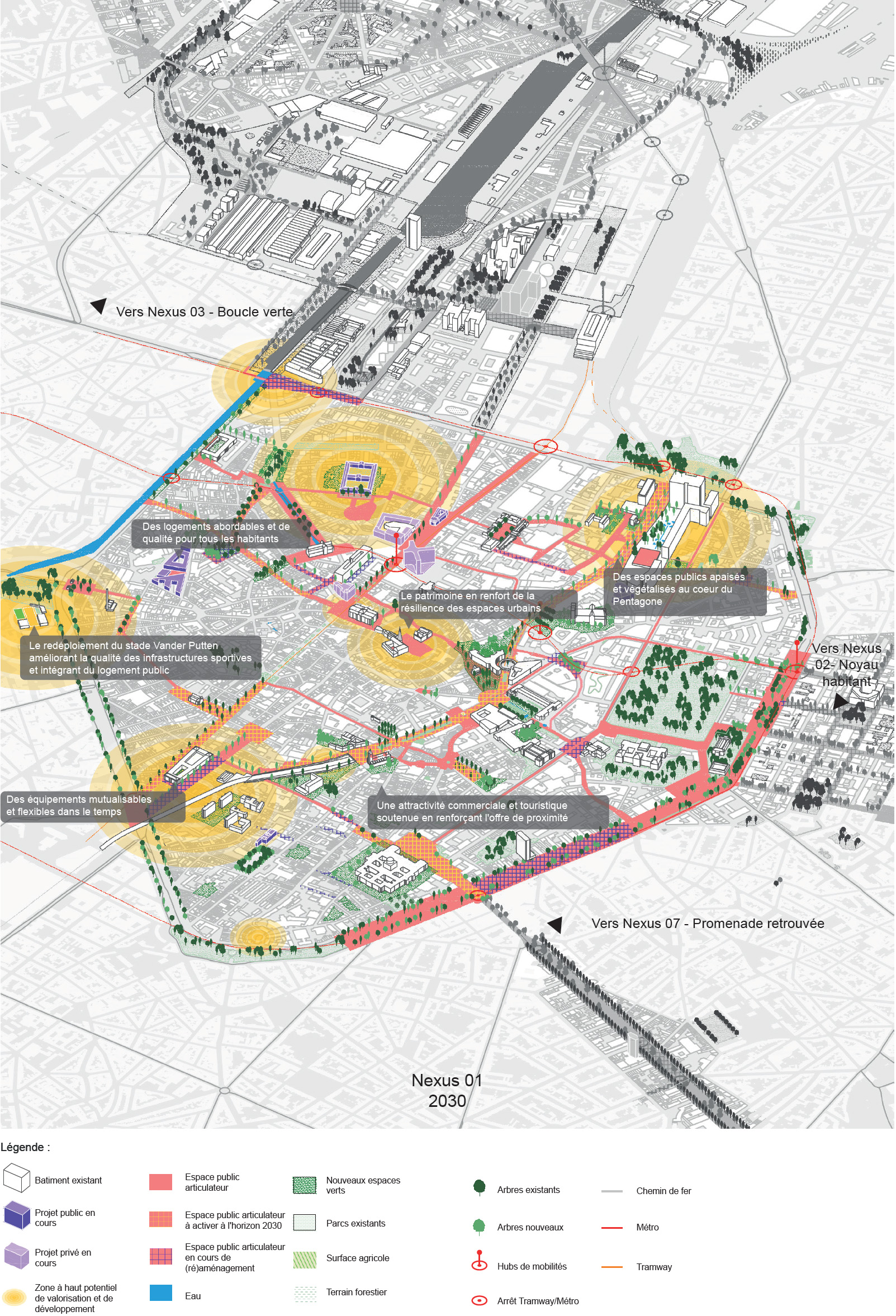
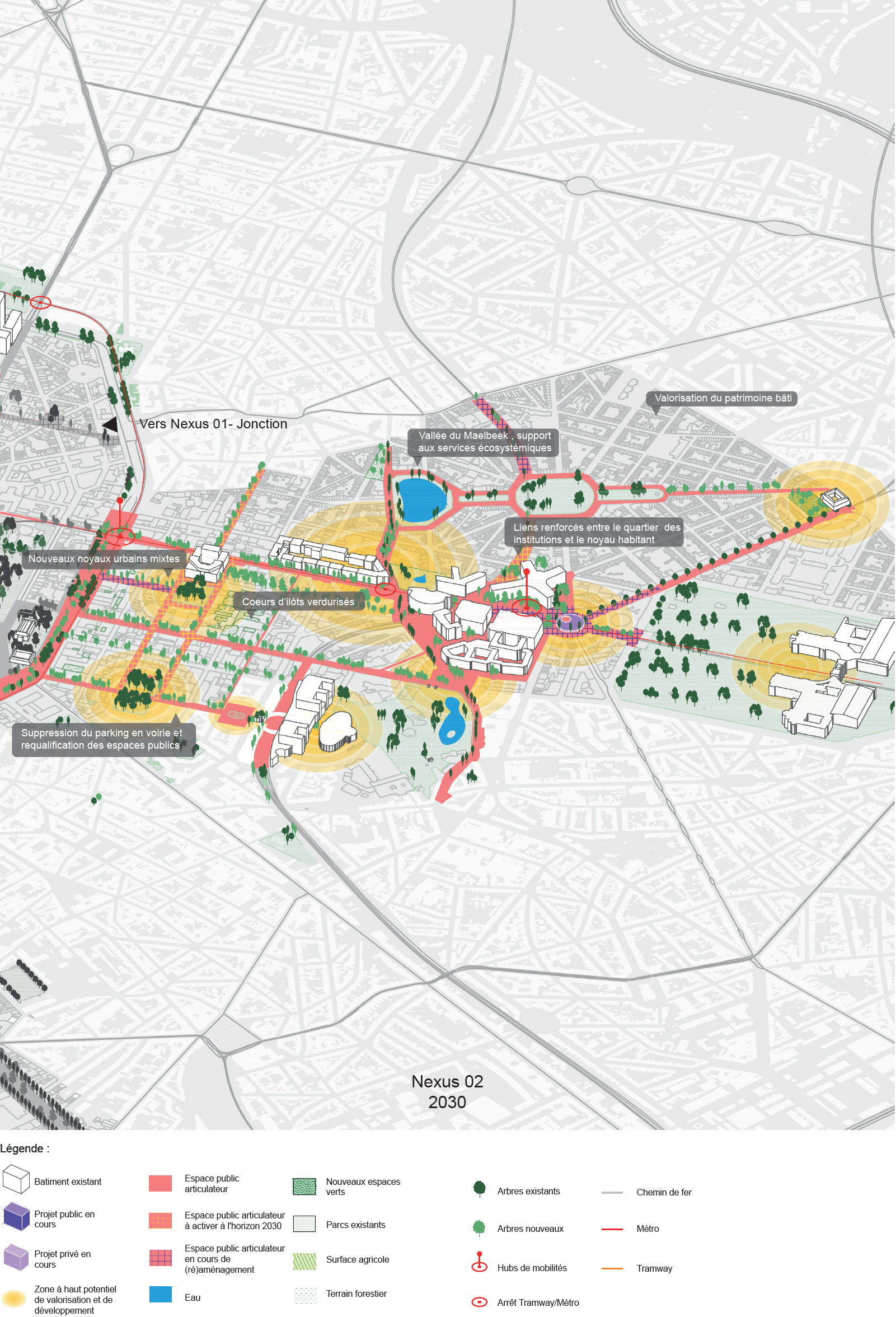
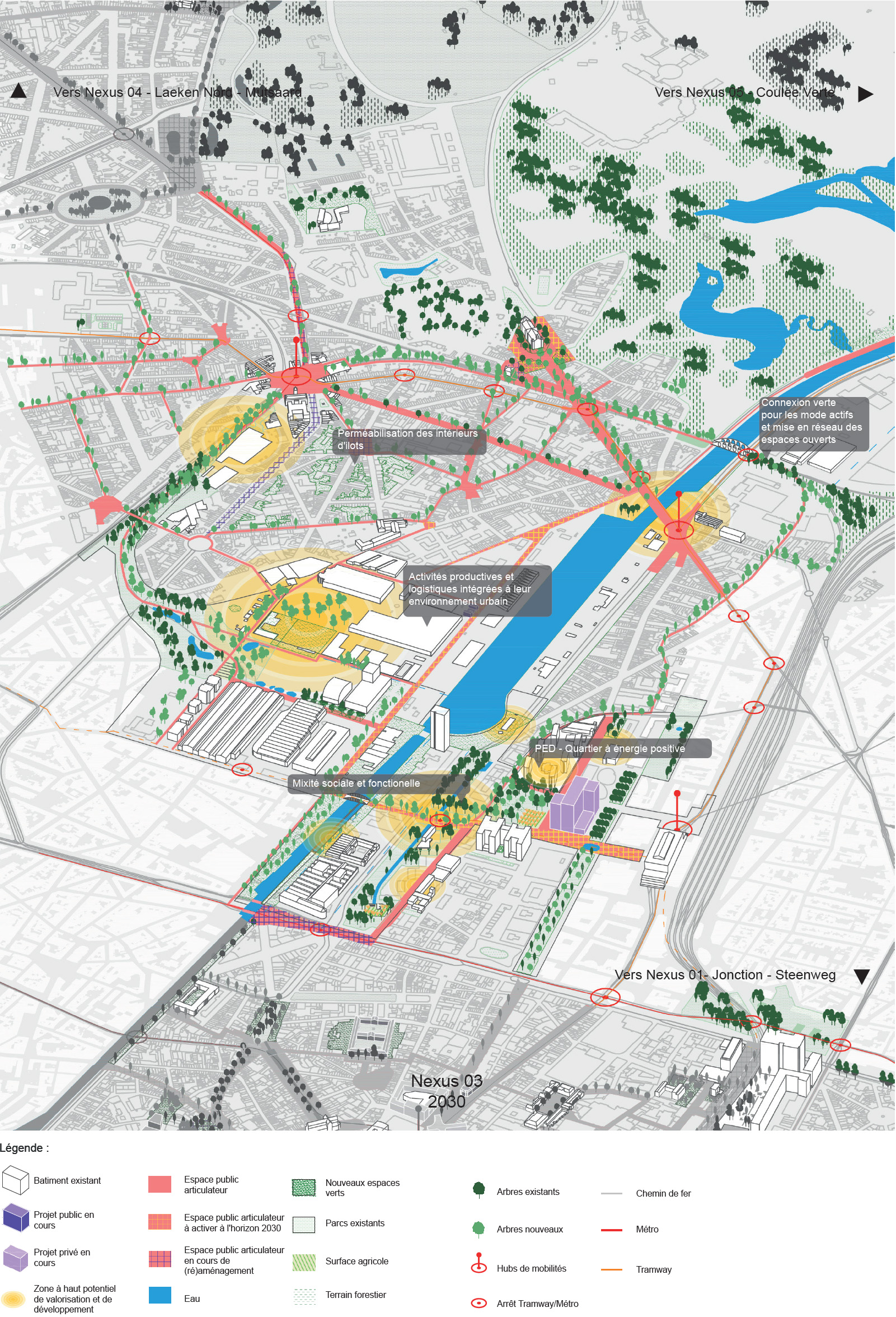
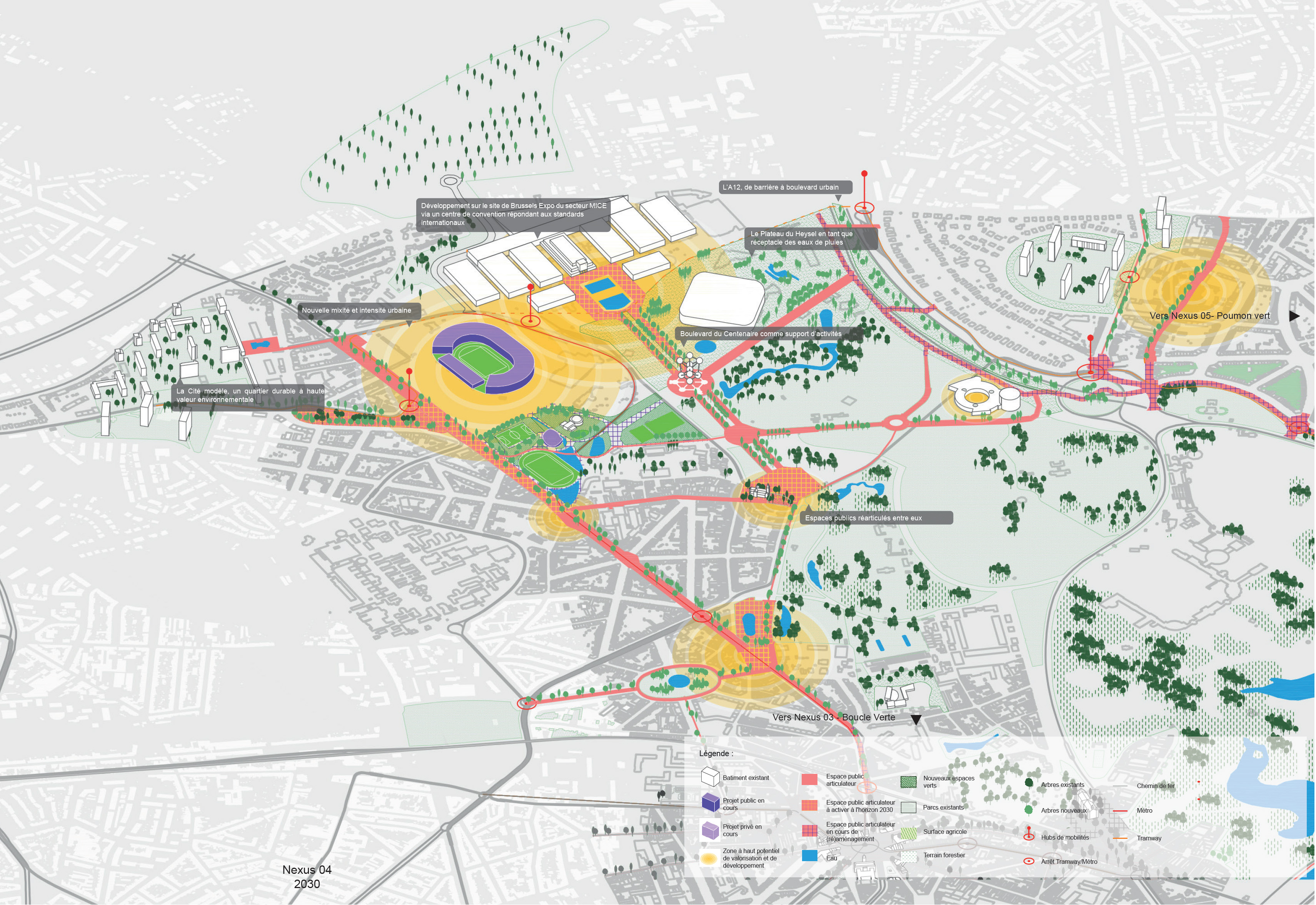
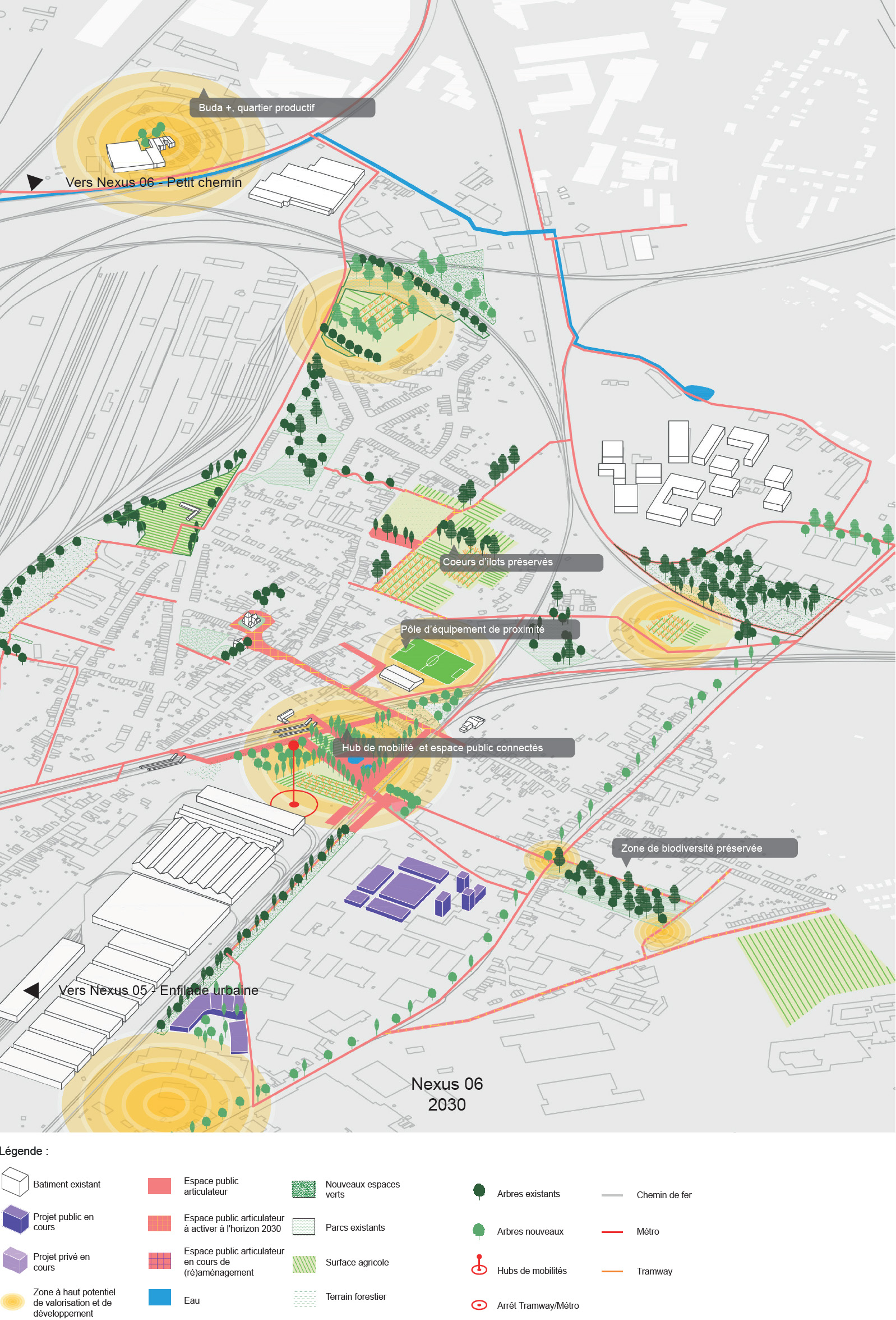
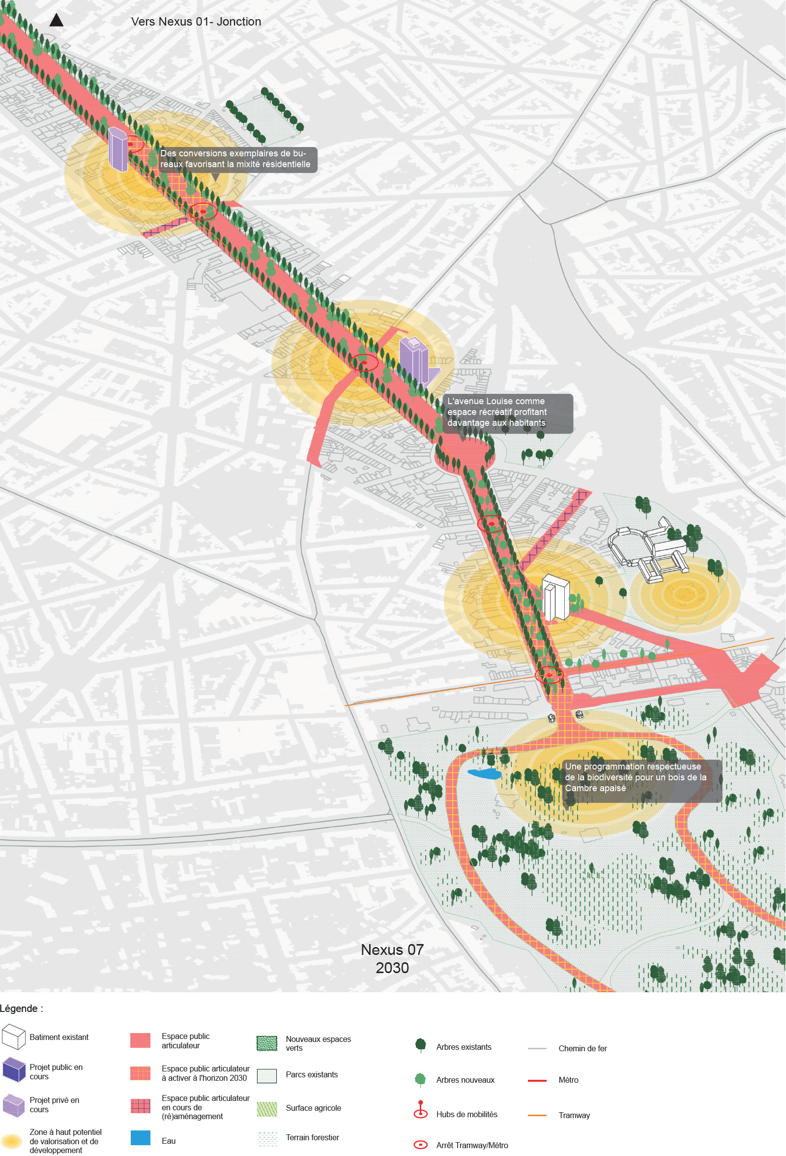
As the spatialisation of projects and actions is at the heart of the objectives, 7 priority intervention zones have also been identified, programmed and specifically mapped. These 7 'Nexuses' (understood in the rare sense of 'complex network', link, connection or node) are geographical areas with high strategic potential in which the Plan recommends concentrating physical projects and actions linked to public space and buildings in order to respond to the 7 cross-cutting ambitions and to have a leverage effect on the scale of one of the 7 quarters.
Pentagon
As the centre of attraction for Brussels, the Pentagon is a major cultural and tourist, economic and commercial, institutional and political hub for the Region. Although it is perceived as a coherent whole bounded by the inner ring road, the Pentagon reveals a multitude of distinct neighbourhoods with varied socio-economic characteristics, different densities, specific commercial dynamics and varying levels of local facilities.
In a context of growing short-term tourism, one of the Pentagon's central challenges is to support the functions of the 'visited City', which create activities and jobs, while developing its qualities as an inhabited city.
North-East Quarter
The North-East zone is made up of two districts with very distinct and different characteristics. On the one hand, the district known as 'Leopold' stands out for its offices, its tertiary activities and its role as an international decision-making centre, thanks to the notable presence of the European institutions. On the other, the 'Squares' residential area boasts a remarkable heritage of buildings and public spaces. These two districts are connected by the Maelbeek valley, creating a unique landscape where water and green spaces blend harmoniously.
Today, the area is undergoing radical change, with clear ambitions for the Leopold quarter. The aim is to transform this former office district into a neighbourhood with a much stronger functional and social mix.
North Quarter - Lower Laeken
On either side of the canal, this urban area encompasses a number of neighbourhoods with unique identities: new mixed-use areas under development, a single-function office district, densely populated neighbourhoods, productive activities,... This fast-changing area is at the heart of numerous urban renewal and planning projects. This transformation is attracting a significant flow of investment, both private and public.
As the owner of a large number of landholdings in the area, the City of Brussels plays a central role in supporting development towards a sustainable neighbourhood. The aim is to create high-quality public spaces and green areas, while ensuring access to affordable housing and local services. At the same time, it is important to maintain production and logistics activities in this changing area.
Upper Laeken - Mutsaard
The north of Laeken is boasting a rich and diverse heritage, an international tourist hub and many large, high-quality green spaces, but it also includes residential areas typical of second-ring developments. On the other side of the A12 and the Heysel plateau lies the highly residential Mutsaard district, which is relatively isolated due to the lack of east/west connections with the rest of Laeken.
Today, major investments are ready to be made to transform the north of Laeken into a new mixed urban district. These projects also focus on the existing parks in order to enhance them.
Neder-Over-Heembeek
This district, once a village in the heart of the Senne valley, is now isolated due to a lack of connections with neighbouring districts and a lack of access to the canal. This territorial complexity means that the village is in a state of balance between its rural past and its present, characterised by housing and industry. Despite this fusion of influences, vestiges of its history remain in some areas, even though population growth is putting significant pressure on the district's green natural setting.
The challenge is to connect this part of the area to the rest of the City of Brussels, ensuring exemplary and balanced urban development in terms of preserving and enhancing its natural heritage.
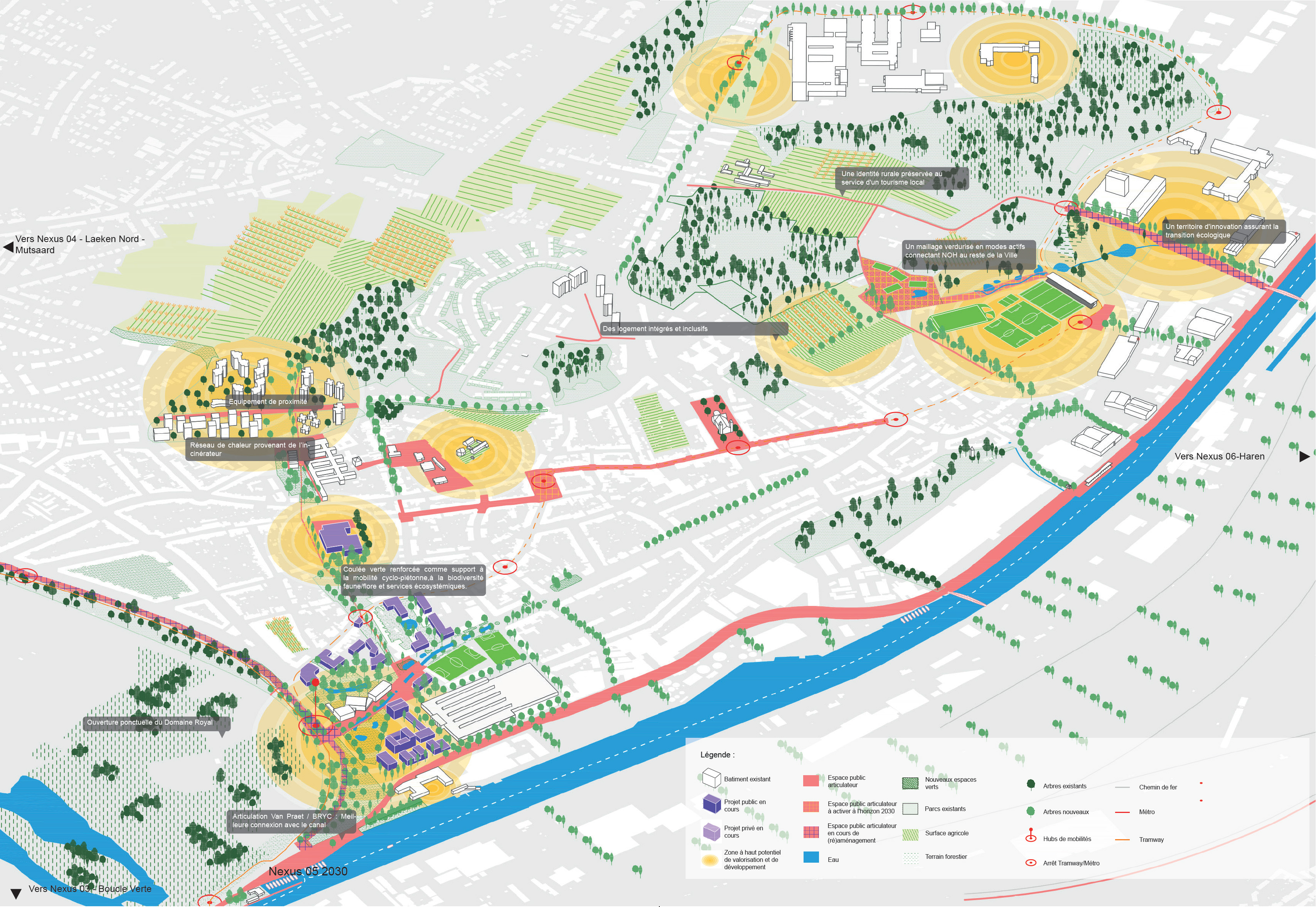
Haren
Haren is an area with two distinct facets: on the one hand, an off-centre residential area offering beautiful views, a rich heritage testifying to its rural past, and a dense network of paths and tracks embellished with vast open spaces and vegetable gardens. On the other hand, Haren is home to major economic activities, with a variety of businesses and large-scale infrastructures that cause a great deal of nuisance, encircling it and isolating it from the surrounding neighbourhoods.
The main challenge for Haren is to accommodate sensible residential and economic development structured by a network of high-quality green and blue public spaces conducive to active mobility for pedestrians and cyclists, and to make the most of its natural and built heritage.
South territory
The southern part of the City of Brussels is an area wedged between several other Brussels municipalities, made up of various districts, each with its own unique identity. On one side, the Avenue Louise, once conceived as a promenade for the upper middle classes, has gradually given way to cars and office buildings. On the other, to the south, are the green and airy neighbourhoods that stretch around the Bois de la Cambre.
The challenge is to strike a balance between calming car traffic and enhancing the area's many architectural and landscape assets. The recent reduction in the number of offices in the northern part of the Louise quarter provides an opportunity to diversify the housing and green the courtyards and gardens, which are currently densely built-up.
The public enquiry runs from 13 December 2023 to 26 January 2024.
During the entire duration of the public enquiry, the file can be downloaded below (under Documents). The file is also available for inspection at the City of Brussels: Rue des Halles 4 - 1000 Brussels.
- Monday to Wednesday: from 8:30 am to 4 pm, Thursday from 8:30 am to 6 pm, Friday from 8:30 am to 1 pm
- Thursday from 4 pm to 8 pm (by appointment only: 02 279 30 20)
Comments and complaints can be formulated during the above-mentioned period of the enquiry, either:
- in writing to the Board of Mayor and Aldermen, at the following address: Department of Urban Development - Secretariat of the Consultation Committee, Rue des Halles 4 - 1000 Brussels
- by e-mail to the following address: urb.commissionconcertation@brucity.be
- via the online form
- orally during the public enquiry with the designated official, by appointment only (tel. 02 279 30 20)
Anyone can request to be heard in their comments or complaints by the Consultation Committee that will meet on 6 February 2024 at the City of Brussels (Rue des Halles 4 - 1000 Brussels) at a time yet to be determined.
The order in which the file will be dealt with in the Consultation Committee will be announced on Agenda and advice or will be available on request from the Urban Development Department 15 days before the committee meeting.
Documents in French:
External site PCDD Ambitions
PCDD Nexus (PDF, 14.64 MB)
PCDD Action Plan (PDF, 10.88 MB)
Annexes:
- Environmental Impact Report (PDF, 7.37 MB)
- Environmental Impact Report - non-technical summary (PDF, 757.40 KB)
Documents in Dutch:
External site GPDO Ambitions
GPDO Nexus (PDF, 15.47 MB)
GPDO Action Plan (PDF, 10.87 MB)
Annexes:
- Environmental Impact Report (PDF, 7.17 MB)
- Environmental Impact Report - non-technical summary (PDF, 729.55 KB)
Between 14 October and 30 November 2019, an online survey was held among the population of Brussels to find out their wishes and concerns about the future of the City and their neighborhoods. The aim of this survey was to enrich the municipal plan for sustainable development 'The City in the Making', which is currently being drawn up.
Survey results (PDF, 3.99 MB) (in French)
Survey results (PDF, 3.91 MB) (in Dutch)
In October 2020, workshops with experts took place to indicate strategic objectives and propose actions. These were supplemented by meetings with key players, associations and local residents via virtual walks.
The old development plan from 2004 is therefore completely revised. The details of the old Municipal development plan (goals, diagnosis,...) are only available in French and Dutch:
- Municipal development plan (in French)
- Municipal development plan (in Dutch)